Author Topic: A Thought on Artik's Program.  (Read 677 times)

Offline bustr

  • Plutonium Member
  • *******
  • Posts: 12436
A Thought on Artik's Program.
« on: April 26, 2018, 03:56:04 PM »
After creating custom heightmap files to do the primary land block creation in my terrains, I have a thought about Artik's program for MA terrains.

I have to create layer templates in my 1:1 blueprint that ultimately my base topographical profile comes out of that is turned into a RAW import file. One of the layers evenly divides a square into 3 countries since the actual combat area is a circled 10 sectors or 20 sectors in diameter. All the corners are empty space you have to creatively fill like you have seen with my new terrain riftval.

I use layers to create all the elevations in a 16bit grayscale png file. When I have what I want I merge and achieve clean noise free edges between all the the elevations. Then I convert that for import into the terrain editor. Very simple to do. And now after riftval, I know how to edit a whole CBM map with an arena sized 2D topographical foundation to create a world much quicker than the time I just spent developing the skill. In that map below, I built everything with 2D topographical profiles drawn onto the land by hand. Still how else was I going to get my custom result that no geo map on earth looks exactly like this? But, the topographical formations all over the world do which the Artik program can produces endless examples of.

My thought is take "however many" geo converted maps created by the Artik program, scale them the same first, then make a template to highlight a section you want and put that in a layer controlled by a master over lay divider layer. At which point you can rotate the thing to fit if you want everything to radiate from the center. I did that to ensure my three countries in riftval were meeting at the center of the rift valleys that define the boarder. Along with I created all the elevations as separate rings in separate layers.

Once you have all the sections from different geo converted heightmaps in layers, merge and you have a new import file. After it pops up the land in the terrain editor, use a little artistic elbow grease like I do to blend the transitions and paint the thing. Then figure out how to plop in the feilds without damaging too much of the topography you worked so hard to get into the terrain editor. Getting to an import file for this would probably take about a week of futsing around versus my last 5 months of learning how to scale and create a more real world like topography with the AH terrain editor and the limitations of the polygons. Those polygons are a freaking bite when they are laughing at you every single day.....

And before anyone poops on this, have any of you tried to accomplish this with several export files from the Artik program? Wonder if Photo Shop will not allow RAW files to be layered and you would have to convert the cliped parts to 16bit grayscale png, and convert the finished file back? Still much easier than my way that takes about 6 months an MA terrain. Would it not be easier if you could pick and choose parts of different geo maps and combine them into one raw file for import? Then you really would not have to learn the terrain editor, just how to generally blend a few things and how to paint.


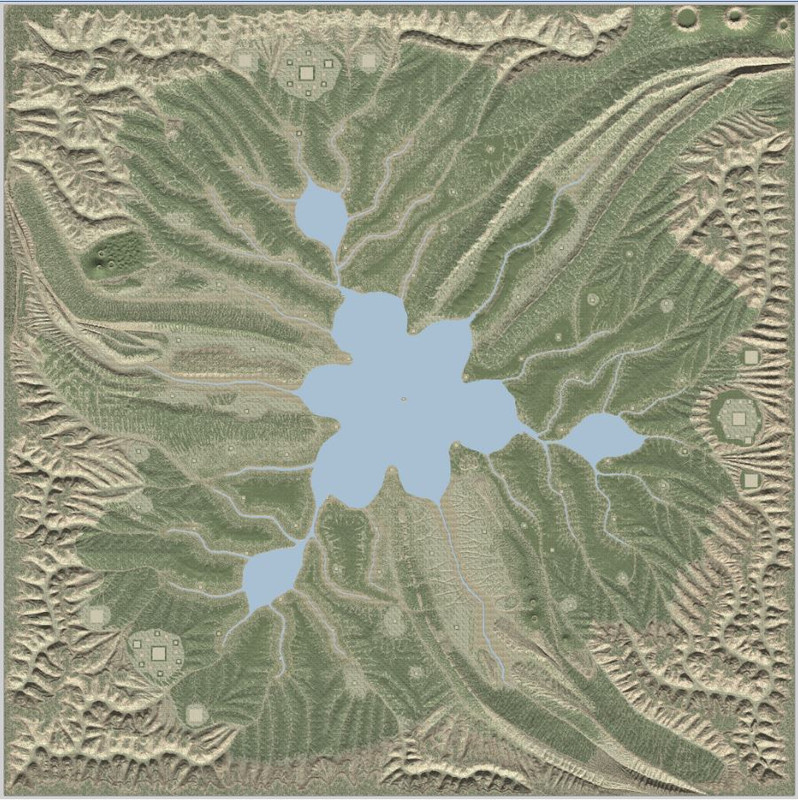
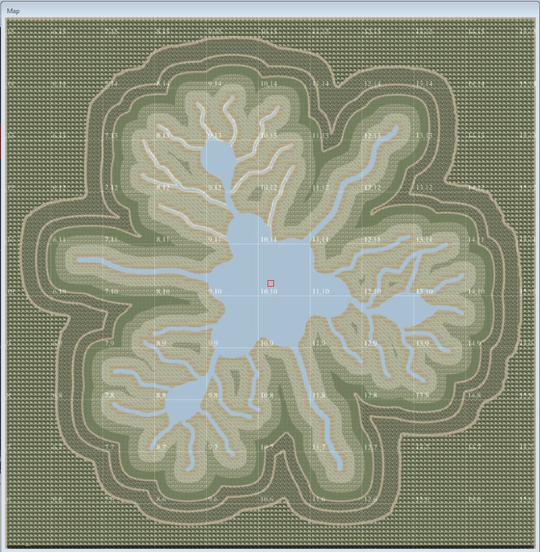
Cause this was a whole lotta work researching the topography, using the TE tools to their limits, and artistically with the tile blending and color limitations which suck. I just wanted to see if it could be done with the AH terrain editor old school style becasue MA terrains have always been so clunky in most cases, and not resort to simpler work arounds. You can imagine the amount of work it took from the two screen shots below. The first one is the finished topography and the second one I painted the day I first imported it 5 months ago to contrast the elevation bands.


Honestly this is what I did in the terrain editor and it's very simple. Right out of 8th grade science class. Seems to me after three terrains Artik's program and futsing around in Paint Shop would be a way to get more none artists trying MA terrains. Geo maps don't make you pull it out of thin air on a blank terrain surface. It is tough enough getting a handle on the strategy of field and spawn layouts while setting up all that game infrastructure which can take another month or so.

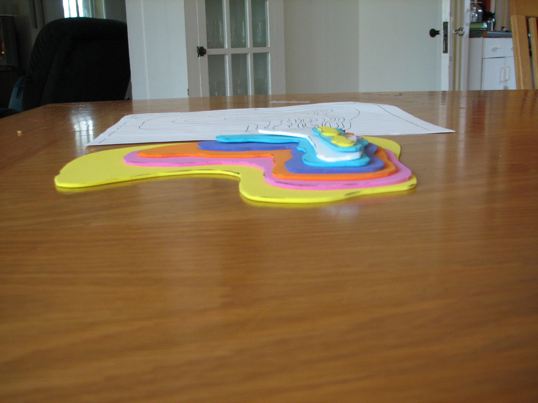
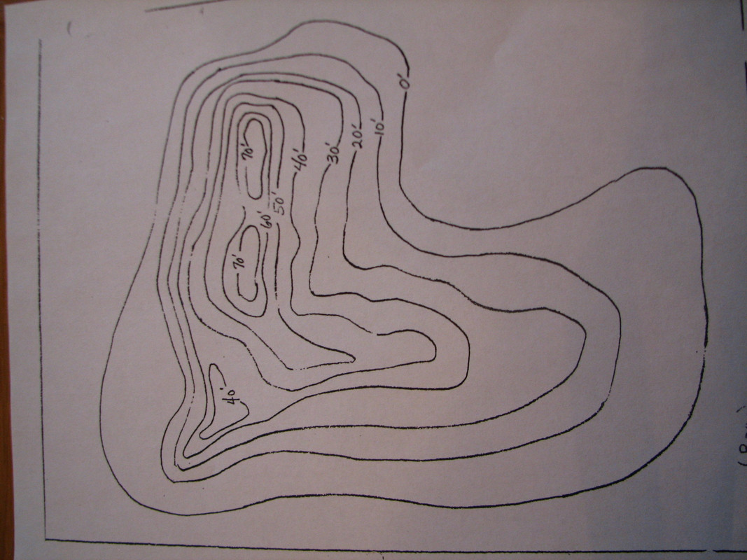
I drew topo guides like this on the CBM area I was working in an art program, then transferred from the CBM. You can do the whole terrain in the CBM in one go or bites at a time. That map won't go anywhere, it's always waiting to laugh at you..... :lol


Raised them with the elevation tool brush, then got artsy on it's kester.


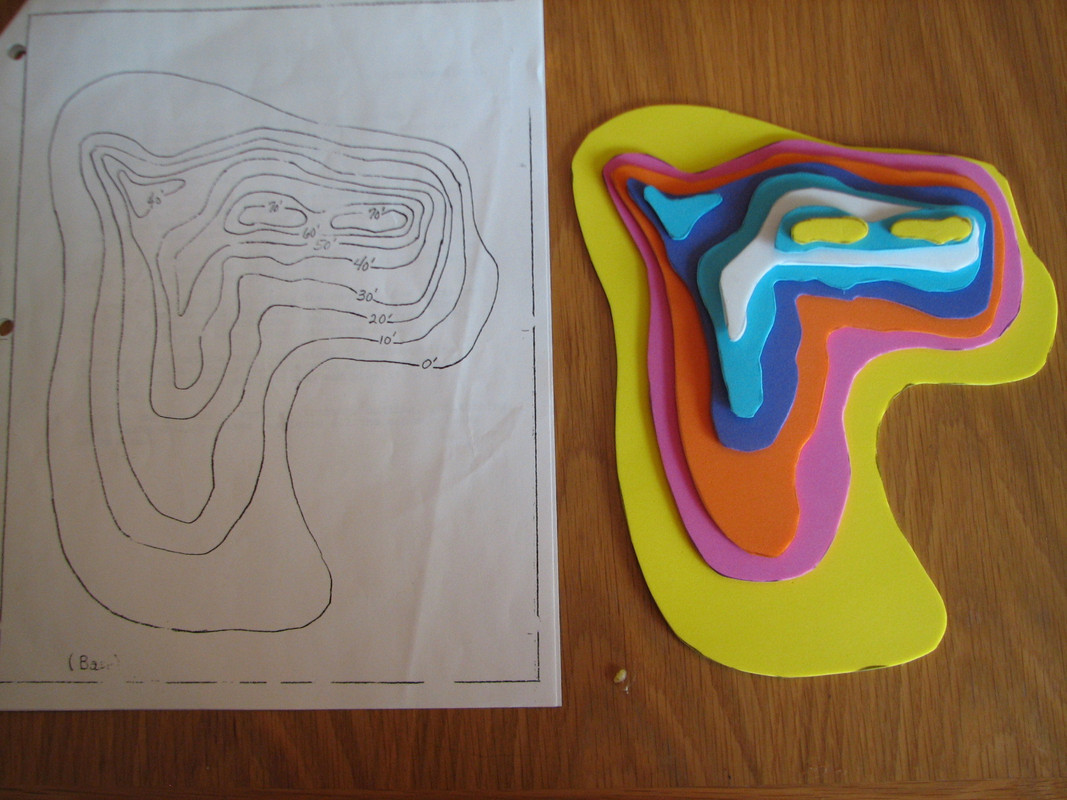
Most of us should have made things like this way back in Primary Ed science classes.


bustr - POTW 1st Wing


This is like the old joke that voters are harsher to their beer brewer if he has an outage, than their politicians after raising their taxes. Death and taxes are certain but, fun and sex is only now.

Offline Ciaphas

  • Silver Member
  • ****
  • Posts: 1955
      • DethKlokDave
Re: A Thought on Artik's Program.
« Reply #1 on: April 26, 2018, 04:25:02 PM »
There are only two things that may not play nice.

1. The RGB values 0-127 for land mass altitude.

The bits that you try to match together will have a gradient of sorts already added to them. Making the different components conform with each other might be a bit bothersome.

2. RGB 254, 255 and 256 used for ocean.

Photoshop for the most part is going to blend all half pixels from black to white unless you work with pixel snap enabled and rely one the “create beaches” function to smooth them out in the editor.

Also, running the make beaches command with any ground set at RGB: 1 will give some very interesting results and will more than likely make you reset the .raw file in the TE.


Sent from my iPhone using Tapatalk
10.(Jabo)/JG 26 Nuisance Raids Scenario


Offline bustr

  • Plutonium Member
  • *******
  • Posts: 12436
Re: A Thought on Artik's Program.
« Reply #2 on: April 26, 2018, 07:40:49 PM »
I wrote, then you use some artistic elbow grease like I do in the terrain editor after you import the kludge to artfully blend where all of those pasted in parts meet. And if you can arrange each part on it's own layer over a master layout layer, then merge them together, the edges are clean with little to no noise. I have to do that when I create the elevations as individual layers for my terrains.

With a 16bit grayscale png file sea level is gray value 1000 all the way to max elevation allowed in the terrain editor is 32k or gray value 33000. Guess I'll have to find a way to make it happen after I get riftval submitted. I'll see if I can open an Artik file in Krita or open it in Photo Shop, clip what I want and paste that into a Krita multi-layer png to come up with a solution. It will cut out having to purchase and really learn L3DT or the terrain editor like I have lived in about 18 months now, other than to massage the meeting boarders of the clipped parts after the import. And painting the masterpiece, hmmm, art lessons online.......  :huh

Or ask themselves, self, when it rains, where does the water go??

The MA is not the SEA or AvA and terrains are a bit different. I want to make it possible to use Artik's program to create libraries in essence, of usable real world topographical features to simplify suffering through manually creating them like I do. I don't understand why he did not program the ability to outline an area then use only that as an export to create reusable topography libraries. The MA is a fantasy world with three countries played in by people who just want go piu, piu, piu. The ones who want to fly WW2 and all the visual realism show up for the weekly and monthly events like my squad does and they are two sided conflicts. Easyscor and company have that covered from end to end with Artik's single purpose driven application.

bustr - POTW 1st Wing


This is like the old joke that voters are harsher to their beer brewer if he has an outage, than their politicians after raising their taxes. Death and taxes are certain but, fun and sex is only now.

Offline artik

  • Silver Member
  • ****
  • Posts: 1907
      • Blog
Re: A Thought on Artik's Program.
« Reply #3 on: April 28, 2018, 01:49:55 PM »
To be honest I thought of several things regarding MA terrain generation using real world topography features.

I thought of 2 directions:

Simulated erosion

1. You create some basic topography that you have in mind using different colors in any editor
2. The program starts rains and simulates natural erosion process

Something like this: https://www.youtube.com/watch?v=9kLoZShDr0o

I tried to do some simple prototypes but didn't get good results yes - it requires more work to do so the generated erosion would look natural.

But right now I have very limited time to spend on it.


Machine Learning Methods

There are lots of systems appear recently that allow to create naturally looking artificial images, so such techniques may be applied to add "erosion" to the manually written scenery.


Copy-Paste-From-Natural World

Just take some nice terrain features paste them into real terrain rotate and use them. You need decent 16 bit graphical editor. And maybe some post processing. (But nothing on my part)

If you need me to export the output to some other format that is readable by some software I can add it (unless it is crazy complex format).


@hitech note my terrain generation program in 100% open source under permissive MIT license - so it can be imported and merged into TE and extended for an additional features.
Artik, 101 "Red" Squadron, Israel

Offline bustr

  • Plutonium Member
  • *******
  • Posts: 12436
Re: A Thought on Artik's Program.
« Reply #4 on: April 28, 2018, 06:19:21 PM »
After looking at your program's results flying in FSO and building heightmaps converted from 16bit grayscale to raw from scratch for my terrains. It has been apparent I could probably generate several heightmaps with your program, then clip what I wanted using a guide template and pasting the parts into a 4096x4096. Then import into the terrain editor though, I wonder if copy and pasting parts of RAW files into another file would end up need to be reconverted to raw again? Cleaning up the boarders where all the different clipped sections meet, maybe a day being creative in the terrain editor.

I was thinking about experimenting with that after I finish my current project. Now if you can write a tool to allow clipping those inside of your program and merging them there before exporting for the AH terrain editor. Or exporting those to create a topo object library to be reused in your program or compatible with other art programs. Who knows, maybe more players would create MA terrains that require a 3 country venue. Then it would not take them 5 months to manually create a 2048x2048 topographical profile in 2D by hand and manually create the 3D result from the 2D with the sculpting tools in the terrain editor. Your program would do it for them in a day and leave it up to them to be a tiny bit artistic blending the parts and painting the whole project space.

Getting started from scratch seems to be the hardest hurdle for many in trying terrain building. At least with your program they can pick and choose locations that can be looked at before running your program. The way I do it, I'm removing everything from a block of granite that is not the work of art I can see in my head hidden in the block of granite. Seems that is too old school for many today..... :O
bustr - POTW 1st Wing


This is like the old joke that voters are harsher to their beer brewer if he has an outage, than their politicians after raising their taxes. Death and taxes are certain but, fun and sex is only now.