he was near mountains?
possibly windshear? downwash from wind crossing the mountain?
Large-Scale Vertical Waves (Mountain Waves)
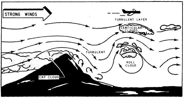
Mountain waves occur on the lee side of topographical barriers and occur when the wind-flow is strong, 25 knots or more, and the flow is roughly perpendicular to the mountain range. The structure of the barrier and the strength of the wind determines the amplitude and the type of the wave. The characteristics of a typical moun-tain wave are shown in figure 3-3-9.
Figure 3-3-9 shows the cloud formations nor-mally found with wave development and il-lustrates schematically the airflow in a similar situation. The illustration shows that the air flows fairly smoothly with a lifting component as it moves along the windward side of the mountain. The wind speed gradually increases, reaching a maximum near the summit. On passing the crest, the flow breaks down into a much more com-plicated pattern with downdrafts predominating. An indication of the possible intensities can be gained from verified records of sustained downdrafts (and also updrafts) of at least 5,000 feet per minute with other reports showing drafts well in excess of this figure. Turbulence in vary-ing degrees can be expected and is particularly severe in the lower levels; however, it can extend to the tropopause to a lesser degree. Proceeding downwind, some 5 to 10 miles from the summit, the airflow begins to ascend in a definite wave pat-tern. Additional waves, generally less intense than the primary wave, may form downwind (in some cases six or more have been reported). These are similar to the series of ripples that form downstream from a submerged rock in a swiftly flowing river. The distance between successive waves usually ranges from 2 to 10 miles, depend-ing largely on the existing wind speed and the at-mospheric stability. However, wave lengths up to 20 miles have been reported. It is important to know how to identify a wave situation. Pilots must be briefed on this
condition so they can avoid the wave hazards. Characteristic cloud forms peculiar to wave ac-tion provide the best means of visual identifica-tion. The lenticular (lens shaped) clouds in the upper right of figure 3-3-9 are smooth in contour. These clouds may occur singly or in layers at heights usually above 20,000 feet, and may be quite ragged when the airflow at that level is tur-bulent. The roll cloud (also called rotor cloud) forms at a lower level, generally near the height of the mountain ridge, and can be seen extending across the center of the figure. The cap cloud, shown partially covering the mountain slope, must always be avoided in flight because of turbulence, concealed mountain peaks, and strong downdrafts on the lee side. The lenticulars, like the roll clouds and cap clouds, are stationary, constantly form-ing on the windward side and dissipating on the lee side of the wave. The actual cloud forms can be a guide to the degree of turbulence. Smooth clouds generally show smoother airflow in or near them with light turbulence. Clouds appearing ragged or irregular indicate more turbulence. While clouds are generally present to forewarn the presence of wave activity, it is possible for wave action to take place when the air is too dry to form clouds. This makes the problem of iden-tifying and forecasting more difficult.


