http://www.weathergraphics.com/tim/af447/Very good discussion on the weather conditions at the time conducted by a USAF guy who did the forecasting forthe sector between Mombasa, Kenya and Cairo, Egypt for C-5 and C-141 aircraft. I'm posting the text and graphics.
-------
Air France flight 447 (AF447), an Airbus A330 widebody jet, was reported missing in the equatorial Atlantic Ocean in the early morning hours of June 1, 2009. The plane was enroute from Rio de Janeiro (SBGL) to Paris (LFPG). Speculation suggested that the plane may have flown into a thunderstorm. The objective of this study was to isolate the aircraft's location against high-resolution satellite images from GOES-10 to identify any association with thunderstorm activity. Breakup of a plane at higher altitudes in a thunderstorm is not unprecedented; Northwest Flight 705 in 1963 and more recently Pulkovo Aviation Flight 612 in 2006 are clear examples.
Back in the 1990s I did flight route forecasting for the Air Force. One of my assignments in summer 1994 was forecasting was the sector between Mombasa, Kenya and Cairo, Egypt for C-5 and C-141 aircraft. The Sudan region had tropical MCS activity similar to this with little in the way of sensor data, so this incident holds some special interest for me as one of our C-5s could easily have followed a very similar fate. Using what's available to me I decided to do a little analysis and see if I could determine anything about the fate of AF447 and maybe through some circuitous, indirect means help give authorities some clues on where to look.
1. Reports and evidence
Reports indicate AF447 reported INTOL (S01 21.7',W32 49.9' or -1.362,-32.832) at 0133Z and was to proceed to TASIL (N4 00.3',W29 59.4', or +4.005,-29.990) in 50 minutes (a true track of 28.1 deg) (source) indicating that it flew high altitude route UN873 (see below).

Enroute High Altitude Caribbean and South America H-4, 30 AUG 2007 (National Geospatial-Intelligence Agency)
Though the actual flight plan data was not accessible to me, this corresponds well with an actual flight plan found on the Internet for a Varig B767 from Rio de Janeiro to Frankfurt:
(FPL-VRG8744-IS -B763/H-SIRYW/S -SBGL0110 -N0485F290 PCX3 POKA UA314 NUQ/N0475F330 UA314 SVD UZ10 NTL/M080F320 UN873 FEMUR/M080F320 UN873 INTOL/M080F320 UN873 EPODE/N0476F340 UN873 ASEBA/N0475F340 UN873 SAGMA/M080F340 UN873 CVS/M080F360 UN873 LIMAL/N0463F360 UN873 GDV UN858 SUNID/N0454F380 UN858 DGO UN976 PPN/N0457F360 UN976 LATEK UN871 KUDES T163 PSA PSA2W -EDDF1129 LSZH EDDL -EET/SBRE0050 SBAO0309 ORARO0340 GOOO0355 GVSC0518 GCCC0618 GMMM0746 LPPC0836 LECM0848 LFFF0951 LSAS1042 EDUU1059 EDFF1111 RIF/PPN/N0456F390 UN857 BAN BAN2E LEMD RMK/ETOPS UNDER 120 MIN RULE ENROUTE ALTS SBNT GVAC)
I decided to project the flight forward from INTOL. An altitude of FL350 and speed of 520 mph was given. Presumably this is ground speed according to the ACARS specification. Compensating for a 10 kt headwind as given by the SBFN sounding this yields an airspeed of M.80, which correlates well with the A330's typical early cruise profile. This yields the following aircraft coordinates:
Time Coordinates Description
0133Z -1.362,-32.832 Reported INTOL
0145Z -0.033,-32.125 Extrapolation
0200Z +1.629,-31.242 Extrapolation
0215Z +3.290,-30.357 Extrapolation
0223Z +4.150,-29.876 Estimated TASIL
0230Z +4.951,-29.469 Extrapolation
2. Meteorological analysis
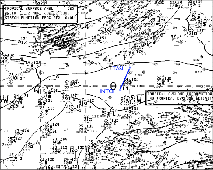
Surface analysis showed the suspected crash region to be within the intertropical convergence zone (ITCZ), which at this time of year is usually found at about the 5-10N parallel. A region of strong trade winds covered most of the tropical North Atlantic and this kept the ITCZ in a somewhat southerly position. The linear convergence along the ITCZ and the unstable atmospheric conditions combined to produce scattered clusters of thunderstorms.

Surface analysis for 0000Z. (NCEP)
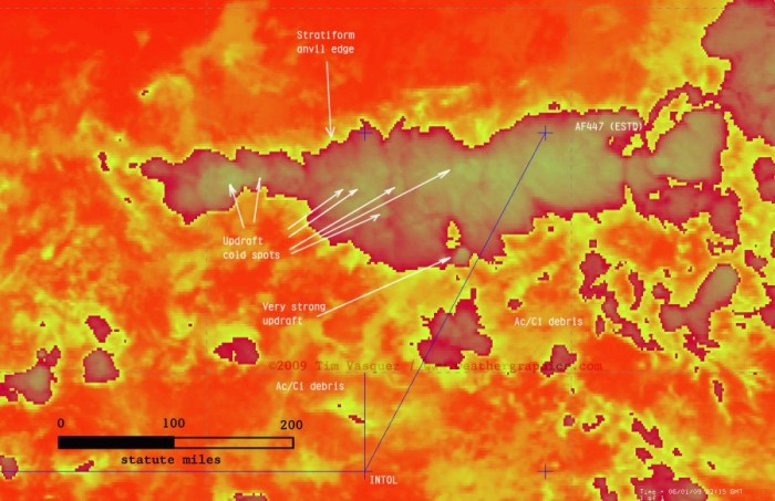
Using McIDAS I acquired satellite GOES-10 satellite data from UCAR and centered it over the region between INTOL and TASIL. I then plotted the waypoints using McIDAS's built-in coordinate entry panel. Since the source satellite images are georeferenced NOAA/GINI datasets, the points shown here are very accurate and are NOT placed by hand but by lat/long coordinates to the nearest 0.001 deg (0.06 mile). In the image below, the stationary southerly point in blue is INTOL and the aircraft's estimated location from the above table is marked with a cross. Graticule spacing is 5 degrees. For the orange temperature plots I used the NCL/3aw curve; the sharp gradient of the enhancement from dark to light occurs at 243K (-30 deg C), indicating a cloud top of FL310 assuming the satellite pixel is completely overcast with that layer (which is not always true).

(Hit reload if you don't see the satellite images in the looper above)
Raw infrared images are also available here: 0145Z, 0200Z, 0215Z, 0230Z.
And finally this image shows a zoomed image at 0215Z when AF447 made its last transmission:

About 90% of the cloud material seen on this image is actually multiple levels of convective debris fields from dying storms and activity that occurred previously during the day, with only scattered cirrus fields at flight level. The active thunderstorm areas are defined by small-scale mottled areas of cold cloud tops. Compare with this structural diagram below of a similar tropical MCS in the same area in 1977. It illustrates that planes inflight are clear of most dangerous weather throughout a tropical system except when directly above an active updraft area.

Schematic of a typical tropical MCS observed in the Atlantic southwest of Dakar on 4 Sep 1974. (Structure and Dynamics of a Tropical Squall-Line System, R. A. Houze Jr., Mon. Wea. Rev., 105, 1540-1567)
It appears AF447 crossed through three key thunderstorm clusters: a small one around 0151Z, a new rapidly growing one at about 0159Z, and finally a large multicell convective system (MCS) around 0205-0216Z. Temperature trends suggested that the entire system was at peak intensity, developing rapidly around 2300-0100Z and finally dissipating around dawn. From a turbulence perspective, these cold spots would be the areas of highest concern as they signal the location of an active updraft producing new cloud material in the upper troposphere.
The last communication from the plane was at 0214Z (12:14 am local meridian time). This was an automated ACARS message reporting an electrical fault and pressurization problem. This would be about the time the plane was beginning to exit the cluster, but not before having flown for 75 miles of numerous updrafts. The exact aircraft location cannot be determined with certainty, however, since a 1-minute time error in position or reporting time translates to 9 miles of spatial error.
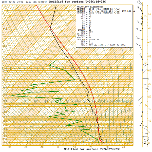
The Fernando de Noronha sounding is available here and shows typical tropical conditions with modest positive energy throughout the column from the surface up to 45,000 ft. There is what looks like anvil level material above 25,000 ft. The significant dry mid-level air is somewhat unusual and suggests the potential for enhanced evaporational cooling in the upper troposphere enhancing downdraft production, and any synoptic-scale lift (if present) enhancing instability through adiabatic cooling of the layer.
I modified this sounding (see below) using the prevailing temperature/dewpoint field across that part of the ocean and modifying for some cooling due to nighttime loss of heating. This is my best guess at the parcel profile that fed this storm. It yields a worst case instability of 1048 J/kg of CAPE, which is moderately strong but considered borderline for typical severe weather. Vertical velocity can be obtained by w=2*CAPE^0.5 yielding a maximum possible updraft speed contribution of 45.8 m/s or 102 mph, though in reality this is usually much less (on the order of half or less) due to precipitation loading and other factors.
