Author Topic: Something for the Pacific Tile Set - 3  (Read 1936 times)

Offline bustr

  • Plutonium Member
  • *******
  • Posts: 12436
Something for the Pacific Tile Set - 3
« on: May 01, 2017, 05:20:57 PM »
Once again starting a new post to keep the load down from all of the screen shots.

Now that I've created the three islands and have the feel for rapid creation of volcanic mountain ridges, I need to create three 4000ft plateaus as the main island of each country. And a highlands home for the strats. I painted in gray rock tile on the raw land block area I want to raise a highland on each island. If you tile paint map the 2D area of your 3D landscape, it suddenly becomes a repetition of set some cylinders down, pull the bulldozer tool between them to make a spine and runoff canyons, then a little blending and cleaning up with the smoothing and raise hill tool. Or you can pull the spine with the elevation tool, then use the bulldozer to pull runoff canyons. Apples and oranges, while painting is the easy part.


So here is the snip showing bases, spawns and strats. On the main island you see a line of three strat and two large aifeilds I want on a 4000ft plateau. It's obvious now where the two ports are located I'll pull a cut to those locations to make a bay. I drew the island in that kind of eroded shape......


Here is the 2D gray rock painted area I will raise up into a volcanic plateau on each island for the strats and large airfields. The width of the gray shape is about 17 miles, so I have room to create long runoff canyons with the top about 5 miles wide. The fuel strat is a 2x2mile object.


bustr - POTW 1st Wing


This is like the old joke that voters are harsher to their beer brewer if he has an outage, than their politicians after raising their taxes. Death and taxes are certain but, fun and sex is only now.

Offline bustr

  • Plutonium Member
  • *******
  • Posts: 12436
Re: Something for the Pacific Tile Set - 3
« Reply #1 on: May 01, 2017, 09:49:13 PM »
Did you know if you set the brush narrow, the bulldozer tool can be used to cut and morph the face of cliffs and walls of escarpments. Short down strokes, and you can use it to clean up an uneven long area by pulling it across which will level all the bumps and pot holes.


Escarpment.


bustr - POTW 1st Wing


This is like the old joke that voters are harsher to their beer brewer if he has an outage, than their politicians after raising their taxes. Death and taxes are certain but, fun and sex is only now.

Offline bustr

  • Plutonium Member
  • *******
  • Posts: 12436
Re: Something for the Pacific Tile Set - 3
« Reply #2 on: May 02, 2017, 12:46:03 PM »
Two important things to remember, nature is messy and not visually proportionally balanced. And the terrain editor is deceptive visually for scale to your eye.


From 50,000 over top of a large structure you can get a better sense for weathering and runoff patterning. I went around and pulled some thick lines that I returned and touched with a brush set at 25% saturation to break up the stark shape of the thick lines. Suddenly you have weathering on rock in a jungle.

Bottom edge of the escarpment from 50,000ft, see the thick gray rock lines I pulled.


The results are subtle, pretty much like nature but, there is a difference.


The top of this escarpment is 5000ft, looks more like 500ft from this perspective. All the weathering had to go some place at an angle down to the ocean. In the second image I pulled all the way back to the shore, that escarpment just doesn't look very tall or as massive as it is. I haven't finished this island because I have to wait until I lay down the airfields, GV bases and ports to tie them into the land and paint it appropriately. I have to run tests with the terrain tiles to come up with a GV friendly combination of tiles and a "Look" for around human populated areas. I've still got two more of these escarpments to create.


bustr - POTW 1st Wing


This is like the old joke that voters are harsher to their beer brewer if he has an outage, than their politicians after raising their taxes. Death and taxes are certain but, fun and sex is only now.

Online Devil 505

  • Aces High CM Staff
  • Plutonium Member
  • *******
  • Posts: 8859
Re: Something for the Pacific Tile Set - 3
« Reply #3 on: May 02, 2017, 02:49:36 PM »
Bustr, I think part of what makes it look so unnatural is the complete flatness of the plateau's top. Also, to my eye, it looks very fake because it has cliffs on all sides with a square shape from above. I can't think of any real world terrain like this at the scale you are working with.

Perhaps the problem with seeing the escarpment scale lays in having your runoff pattern extending too far out from the cliff face. The cliff face is only 1 mile high, but the valleys formed from the runoff are visible as strait lines well over 25 miles long.


Just some food for thought.

Keep up the good work. This map is coming along nicely.
Kommando Nowotny

FlyKommando.com

Offline bustr

  • Plutonium Member
  • *******
  • Posts: 12436
Re: Something for the Pacific Tile Set - 3
« Reply #4 on: May 02, 2017, 06:50:34 PM »
There are a few volcanic plateaus in the world with flat tops, I've had to concede to something in the terrain editor itself for the width because of the objects I want to place on it. And alt for game play reasons. I really need a much more robust crack system with more channels, that has to wait as a touch up after I populate the island with bases. After the bases and strats are populated, then I can tighten up the design.

Now did you even wonder why I prototyped an island with two volcanic ridges on it? Also most people get to your point viewing things in the terrain editor and need more vertical land because they just cannot accept the strange visual scale of things in the terrain editor. This visual perspective issue is one of the reason many terrains in the past have mountains above 2000m which is more average unless you go to places like the Alps, Borneo, Himalayas, northern Rockies. The Appalachians are not much more than 2000m, I lived next to them for about a decade. I used to live near the Hindu Kush and could see K2 on clear days, and I've wall climbed in the Sierras.   

Thank you for your input way too early in this world creating process. I can always give you the project files to carry on from here since you have decided I'm already off course. What I'm doing with these posts is documenting the construction process of specific things to help get people interested and demystify the terrain editor. This is a single feature on an island that is not finished dependent on object placements, and you can see how many islands I have to go. And some of them will have to wait partially finished for object placement. And base objects will dictate micro topographical features in the 6 mile diameter area around them which often dictates a bit more adjustment behind that to the landscape.

Oh, and I still need two bases with spawns down to waste about a week of my time testing the clutter tiles to create (blend and mix tiles) transit terrain from the spawns to the town and the field to the town that is fair to both GVers and field defenders. And then something spiffy for those three way spawns on the tip of each central island at the medium feilds for the same kinds of players who like shooting each other in the tank pit on my first terrain.

So!! where do you want me to scrub my work and start over under your directions boss??  Do you want me to ask Hitech for bowlma back and do that over for you too?? Hitech seems to like that one so he probably won't give it back.

I knew I should have not winged it and created an 11th layer in the blueprint with ridge lines for the early birds like yourself Devil.....   And in the end, I'm the only person who knows what this fantasy thing is supposed to look like, aint I. It is not anyplace that exists anywhere on planet earth. I'm just taking cues from those regions, not reproduce them like using a Tepui to solve a placement problem and keeping bases below 6,000ft. :O

Hey look Mom... Tepuis............... :rolleyes:


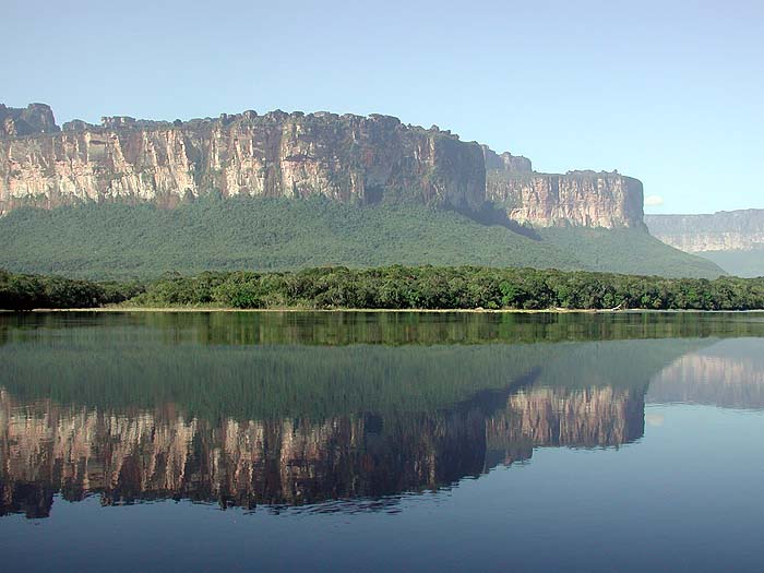
Dang someone form Aces High got loose in the real world and created a Tepui, This thing cannot really exist, I cry foul......So boss where do you want to go with this??


bustr - POTW 1st Wing


This is like the old joke that voters are harsher to their beer brewer if he has an outage, than their politicians after raising their taxes. Death and taxes are certain but, fun and sex is only now.

Offline bustr

  • Plutonium Member
  • *******
  • Posts: 12436
Re: Something for the Pacific Tile Set - 3
« Reply #5 on: May 03, 2017, 11:44:59 AM »
Since someone had to scratch a personal itch just to put in an opinion before asking any questions about what is going on, I have to un-confuse my audience by jumping ahead on a block of terrain building I didn't want to get into yet. I was showing what can be accomplished with the bulldozer tool to create rock features.

You can see I added two volcanic ridges, more will be needed. These are to show how you work your topography down to the ocean. Since water runs downhill and cuts rock as it heads to the sea, you will notice I used the bulldozer tool to cut channels between the Tepui and the volcanic ridges down to 200ft. With those cut, then I perform the finishing work on the runoff canyons that feed water into the lowland.

When I created the Tepui I pulled straight runs off the escarpment just to get a downhill slope I would have revisited it later before someone got itchy. I do have two other islands to duplicate some shape of a Tepui on for the strat and large airfields.

The volcanic ridges were created pulling the backbone, then doing a first run with a narrower brush pulling the side runs all with the bulldozer tool. Then I narrowed the brush again and pulled the cross hatch pattern over those side run areas so when I run a smoothing brush you get those random direction changes in runoff canyons. If you use a wide smoothing brush on the runoff canyons, they will all mostly even out to runoff at the same angle. If you use the smallest smoothing brush that will not get stuck creating then dipping into polygon holes, you will retain the random directions of the canyons.

So these screen shots show a crapload of work I didn't want to get into yet. I'll post the finished examples of these locations later, this is to show the structure of the mountain range using the bulldozer tool, and the 200ft deep channel. I painted the walls of the channel with gray stone to give you a contrast. I'll have to make a pass on the center of the channel at some point with a 25ft elevation because pulling canyons down into it then working them with the smoothing tool will raise the bottom up to about 100ft. One of the problems with doing this free hand, once you start laying in the large features, it's obvious based on looking at real volcanic islands and their topo maps, I have some number of secondary smaller upthrust ridges to lay in.

So here for Mr. Itchy, he should really try his hand at a terrain.


« Last Edit: May 03, 2017, 11:51:52 AM by bustr »
bustr - POTW 1st Wing


This is like the old joke that voters are harsher to their beer brewer if he has an outage, than their politicians after raising their taxes. Death and taxes are certain but, fun and sex is only now.

Offline bustr

  • Plutonium Member
  • *******
  • Posts: 12436
Re: Something for the Pacific Tile Set - 3
« Reply #6 on: May 03, 2017, 01:51:34 PM »
In for a penny in for a pound.

Laid down all the mountain range foundations to map them at 1000ft tall gray colored elevations. And cut down to 25ft between to account for the uplift when I begine pulling canyons and smoothing. How's that Tepui starting to look now that it is being revisited? And I will duplicate some variation on this on two more islands.....

The CBM map is only showing "blocks" that I next have to turn into mountain ranges and interface all the canyons in between. The Tepui is the only flat topped feature for a place to put the strats.


bustr - POTW 1st Wing


This is like the old joke that voters are harsher to their beer brewer if he has an outage, than their politicians after raising their taxes. Death and taxes are certain but, fun and sex is only now.

Offline bustr

  • Plutonium Member
  • *******
  • Posts: 12436
Re: Something for the Pacific Tile Set - 3
« Reply #7 on: May 03, 2017, 05:23:30 PM »
It takes awhile to sculpt landscape. The terrain editor has the same distance visual distortion issues as being in the MA flying around looking long distance at the terrain you are on. Up close terrain looks good, at a distance something you just looked at suddenly has an irregularity. Same in the terrain editor, you are up close cleaning up irregularities in a feature, pull back 20 miles and it suddenly looks like the feature is full of irregularities.

The fine features on the terrain are limited to 1\8 of a mile because that is the smallest brush. Generally making something with smooth features starts at closer to a 1\2 mile brush. The screen shot below has one mountain range finished as far as rock sculpting and painting goes. Overall painting will cover about half or more of the rock you can see with vegetation. Everything on a terrain is constructed from blocks of elevation, then sculpted and smoothed. By painting the area I'm pulling the mountain up from, I do less mountain painting and save some time.

You can see all of the basic block mountains waiting sculpting and blending with the rest of the ranges. The bulldozer tool is like a Swizz Army knife in the many things you can do with it. Pull canyons from a high point, push up and fill pockets. And lay down the basic building blocks for structures. You can't make mistakes because you just use the elevation tool and fill in your booboos.


The red dot is 1\8 mile in diameter.


bustr - POTW 1st Wing


This is like the old joke that voters are harsher to their beer brewer if he has an outage, than their politicians after raising their taxes. Death and taxes are certain but, fun and sex is only now.

Offline bustr

  • Plutonium Member
  • *******
  • Posts: 12436
Re: Something for the Pacific Tile Set - 3
« Reply #8 on: May 04, 2017, 02:27:37 PM »
I decided before I worked on other blocks of mountains and the Tepui on this island, I needed to test some textures and colors. Also how I wanted to hand fill using the "raise hill" tool to add in secondary ridges. The polygon size will dictate your smallest features at which point you have to trade off against no one will ever get on the ground in this area and walk or drive around. Also pulling runoff canyon ridges at certain angles from North\South will result in a line of tall oblong spikes instead of a nice running ridge line. You can waste alot of time fussing with that on a micro scale or, find a way to blend it with the bi-linear smoothing tool. Building mountain ranges like in the screen shot below becomes an effort of diminishing returns if you do not come up with a technique that you can simply lay down the spine and quickly add canyon down sloping ridges. The limitations of the polygons will rapidly defeat your efforts and drive you nutz. 


Some texture and color testing, the tallest peak as a prominent feature is 6000ft.


bustr - POTW 1st Wing


This is like the old joke that voters are harsher to their beer brewer if he has an outage, than their politicians after raising their taxes. Death and taxes are certain but, fun and sex is only now.

Offline bustr

  • Plutonium Member
  • *******
  • Posts: 12436
Re: Something for the Pacific Tile Set - 3
« Reply #9 on: May 04, 2017, 07:17:52 PM »
Given the limitations of the program, this is the closest I can get to a Tepui. That red disk is the smallest brush at 1\8 of a mile which is the polygon limitation to how granular you can make topographical features. the top of the Tepui is 5000ft and the red disk is sitting at 100ft.


Top of this thing in real life is about 3000 meters and the base camp is about 1200 meters. Perspective is strange in real life just as much as it is in the terrain editor.


bustr - POTW 1st Wing


This is like the old joke that voters are harsher to their beer brewer if he has an outage, than their politicians after raising their taxes. Death and taxes are certain but, fun and sex is only now.

Offline bustr

  • Plutonium Member
  • *******
  • Posts: 12436
Re: Something for the Pacific Tile Set - 3
« Reply #10 on: May 05, 2017, 01:56:31 PM »
Tried an experiment just now to see how much I could speed up my mountain process. Instead of pulling the working backbone with the bulldozer tool after laying down the base area blocks. I used a 4mile diameter smoothing tool and sloped the base blocks down from center to the lowlands. Then I used the make hill tool set at 2000 and pulled up all of the ridge lines with a 2mile dia brush. The pulled up ridges have rounded tops, but you can free form branch offs in a hurry. Then visit all of the ridges and branch offs with the make hill tool set to reduce hill using the shift key. You can cut into the side of the rounded ridges and scallop them into a volcanic rock style of ridge line. Follow that up with the bulldozer tool with a very narrow brush to add smaller runoff ridges. Took me about half the time to make the small mountain range left of the Tepui even with the painting.


bustr - POTW 1st Wing


This is like the old joke that voters are harsher to their beer brewer if he has an outage, than their politicians after raising their taxes. Death and taxes are certain but, fun and sex is only now.

Offline bustr

  • Plutonium Member
  • *******
  • Posts: 12436
Re: Something for the Pacific Tile Set - 3
« Reply #11 on: May 08, 2017, 12:46:02 PM »
The last mountain range to finish on Country-1 main island.

Down on the ground level I realized a 5 mile wide open space between volcanic ridges does not happen because of the nature of vulcanism. When you look at the topo maps of islands in and around the Solomons chain, you see the ridge lines crammed together with runoff canyons between them. Creating mountain chains to look randomly pushed up by vulcanism is mind numbing doodling while remembering anything you doodle has to then be turned into a mountain that follows a set of standards, "randomly".... :rolleyes:

My aching finger.....It gets much faster after this, I have my "random standards technique" down. The "raise hill" tool is much faster for pulling up a mountain range while the "bulldozer" tool is better for pulling small ravines, runoff canyons, and leveling the water run base between mountain ridges. It's still a good idea to paint the base area of a mountain or ridge lines, then pull them up with the "raise hill" tool.


Once again scale caught me off guard. Small islands like these were easy to over do the detail because they are one offs. Once I started the large scale mountain range on the big island, the techniques from these tiny islands were out of scale for mass production.


bustr - POTW 1st Wing


This is like the old joke that voters are harsher to their beer brewer if he has an outage, than their politicians after raising their taxes. Death and taxes are certain but, fun and sex is only now.

Offline bustr

  • Plutonium Member
  • *******
  • Posts: 12436
Re: Something for the Pacific Tile Set - 3
« Reply #12 on: May 08, 2017, 07:23:59 PM »
There is a point you reach that it all looks the same and you gotta call it a day.

If you get the hang of it, the "raise hill" tool will perform some interesting morphs if you get the timing down for pulling a ridge line and the speed at which you pull then release the mouse left click button. Still, you can come back in with a smaller diameter brush if you get only a fat sausage, hold down the shift key, and carve it into a finished ridge with canyons.


Finished the whole island mountain range system. Came up with a better tile blend and color for the tops of the Tepui and the run off areas.


One finished mountain system on the main island for Country-1.


It all looks the same to me right now.....too much "Click-1, pull-2, smooth, mush, pull." over and over again.


bustr - POTW 1st Wing


This is like the old joke that voters are harsher to their beer brewer if he has an outage, than their politicians after raising their taxes. Death and taxes are certain but, fun and sex is only now.

Offline bustr

  • Plutonium Member
  • *******
  • Posts: 12436
Re: Something for the Pacific Tile Set - 3
« Reply #13 on: May 09, 2017, 01:44:26 PM »
What did I learn from my first Tepui and mountain range?

Pull the Tepui to it's finished elevation out of the ground. Cut a mote around it to the lowest elevation for the island which is 25ft to include the widest runoff canyons from the Tepui and the expected runoff canyons from the nearest mountains meeting in the center of the moat. Then put in a step all around the Tepui the width of the run off canyons so you can smooth back and up to the edge of the Tepui top. That way I can paint in gray stone the spines of the new mountain range all around the Tepui using it's defined edges to guide my free hand painting. Then with the "raise hill" tool pull all of the mountain spines out of the ground to their finished elevations. After that, a whole lotta pulling run off canyons all over the place.


I'm getting the Tepui in place, it will be a whole project after I get the mountain range defined around it. The red brush is set to 4miles, the Tepui is 5000ft high, and the step is 1500ft.


bustr - POTW 1st Wing


This is like the old joke that voters are harsher to their beer brewer if he has an outage, than their politicians after raising their taxes. Death and taxes are certain but, fun and sex is only now.

Offline bustr

  • Plutonium Member
  • *******
  • Posts: 12436
Re: Something for the Pacific Tile Set - 3
« Reply #14 on: May 09, 2017, 02:30:37 PM »
Tepui raised and main mountain range spines finger painted in with gray rock. Now a bunch of pulling up spines, pulling down run off canyons, and eyeballing free hand small mountain spines as filler. This is a lot of making it up from imagination while remembering the region you researched. And remembering you will have to shoe horn in bases and strats later on after all the fun finger painting is finished.

That gray dot to the right of the Tepui is 1mile in diameter. I put it there so when I opened the map file in an art program, I could set the brush diameter to it. Free hand my mountain spines, open it in the terrain editor and transfer that free hand to the island. I want the runoff canyons on the outside range to drop directly into the ocean this time.


bustr - POTW 1st Wing


This is like the old joke that voters are harsher to their beer brewer if he has an outage, than their politicians after raising their taxes. Death and taxes are certain but, fun and sex is only now.